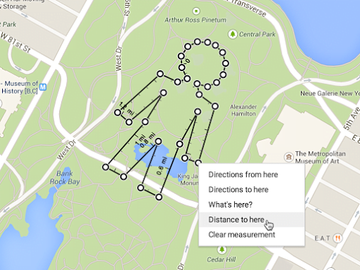
Google Maps on the desktop has bring the new feature that allows you to measure the exact distance between the two points by plotting route on the map.
Google announced this minor but significant feature update in a post on its Google+ page, “Perfectionists, rejoice! The new #GoogleMaps for desktop lets you click and drag to measure your next road trip, bike ride or run—even if you’re taking a few sharp turns.”
Earlier Google Maps gives distance along the planned route when you searched for directions. Now it gives the exact distance between the starting point and the final destination.
To view the distance between points in the new Google Maps, use the right-click menu.
1. Open the new Google Maps and right-click on your starting point.
2. Click Measure distance.
3. Click anywhere on the map to create a path you want to measure. Click to add additional measuring points.
4. You can also drag a point to move it, or click a point to remove it. (This is optional)
5. Look on the map and under the search box for the total distance.
When done, click the “X” in the card under the search box or right-click on the map and select Clear measurement.
This was previously a lab feature in the old Google Maps but is now available as part of the main service.
Related Posts...
What is New!What's Hot
Jun 27th, 2024
On National Doctor’s Day, let’s appreciate the advancements in healthcare, especially the rise of telemedicine. This innovation has revolutionized medical care, making it more convenient and effective. India’s eSanjeevani platform stands out, providing equitable healthcare to all, especially in rural areas. Launched by the Ministry of Health and Family Welfare, eSanjeevani facilitates remote consultations and enhances the quality of care. As telemedicine continues to evolve, driven by technological advancements, it promises to play a crucial role in the future of healthcare, ensuring accessibility and efficiency for everyone.
Read more
Jun 18th, 2024
Learn about the groundbreaking features of iOS 18 and why it’s considered the most impressive update to date. Stay ahead with our detailed insights.
Read more
May 16th, 2024
GPT-4o has arrived. Get the inside scoop on 6 key improvements making OpenAI’s latest natural language model its most powerful yet. We analyze how GPT-4o could change the game for AI applications.
Read more
